Uncategorized

Lumbini Explorer

Thousands of years ago, in the plains of Lumbini, a young queen was on her way to her family home at Devdaha to give birth.However, Prince Siddhartha Gautama, or Lord Buddha as we famously remember him, and his life’s work for, arrived earlier – at the sacred gardens of Lumbini.

Listed as a World Heritage Site, Lumbini and the Greater Lumbini Area, attract millions of visitors annually for its cultural, religious, historical and architectural importance.

History:

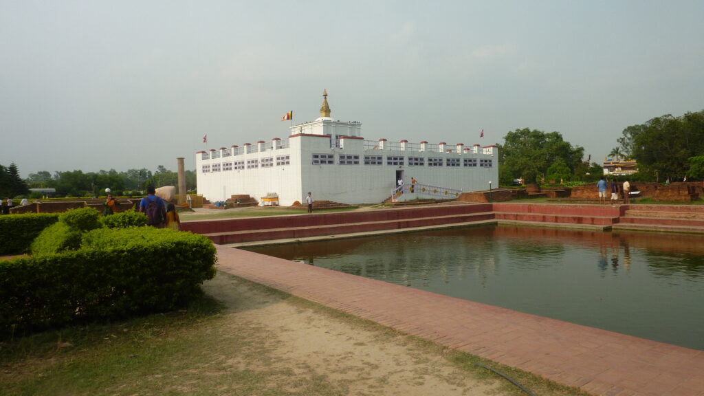
In 623 BC, Lord Buddha’s mother Queen Mayadevi was travelling from Tilaurakot, the capital of the Shakya Kingdom, to her family home in Devdaha to give birth. However, Prince Siddhartha Gautama arrived earlier, at the sacred gardens of Lumbini, where the Maya Devi Temple stands today. Adjacent to the temple is a sacred pool (Puskarini) where Lord Buddha took his purification bath.

Later in his life, Lord Buddha advised his followers to visit four sacred places relevant to his life, one being his birthplace in Lumbini, and the other three being  Bodhgaya, the place where he attained enlightenment, Sarnath, where he delivered his first discourse, and Kushinagar, the place where Lord Buddha passed away at the age of 80.

Lumbini and its surrounding areas have been sites of pilgrimage for centuries – however for a large part of modern history, the exact spot of Buddha’s birth was unconfirmed. It was only in 1896 A.D, when General Khadga Samsher Rana and Alois Anton Fuhrer discovered the Ashoka Pillar, King Ashoka’s visit to Lumbini and his assertion that it was the exact birth place of Lord Buddha was confirmed.

In 249 B.C., Emperor Asoka of the Maurya Dynasty of India, after converting to Buddhism visited Lumbini and the surrounding regions, and erected the Asoka Pillar as a marker of the exact spot of Lord Buddha. Emperor Ashoka, who after embracing Buddhism, helped promote Buddhism across Asia.  

In later years, from 350 – 636 AD, travelers and monks from different eras of time which include Monk Seng-tsai, Traveller Fa-hsien, and Traveller Huan-tsang visited Lumbini and wrote accounts of their visit.

In 1312 AD, Ripu Malla, a Malla era ruler was one of the last visitors to leave evidence of their visit to Lumbini. After that, until the 1896 AD excavation by Khadga Shumsher and Anton Fuhrer, was the archaeological ruins, including the Asoka Pillar was rediscovered which led to an international movement to recognize Lumbini as the birthplace of Lord Buddha.

In 1997 AD, Lumbini was included on the UNESCO World Heritage list.

The Lumbini Master Plan:

According to Sanu Raja Shakya, Member Secretary of the Lumbini Development Trust (LDT), the Lumbini Master Plan, which was formulated in 1967 AD covers an area of 13 square miles and is oriented north-south.

The Lumbini Master Plan, developed by Kenzo Tange, a Japanese architect, includes three zones: (1) the Sacred Garden, (2) the Monastic Zone, and (3) the New Lumbini Village. Each of the zones covers an area of a square mile, and is based on the concept of the path to Enlightenment.  The three zones are connected by a canal which is part of the central link. The area outside the 1 x 3 mile Lumbini Project Area within the 5 x 5 mile zone is the Buffer Zone, which protects the three zones.

Sacred Garden

Comprising of the Mayadevi Temple which includes the Marker Stone to mark the birthplace of Lord Buddha, the Ashoka Pillar, and the surrounding archaeological remains, a visit to the Sacred Gardens, especially if timed in the early morning or late evening will make sure to evoke one’s spirituality. Watch the prayer flags flutter and observe the monks immersed in deep meditation, as you take in more than two millenniums of history in the beautiful and sacred gardens of Lumbini. 

Monastic Zone

Consisting of Buddhist monasteries from around the world, the Monastic Zone while adding immersive value to travelers, offers insight into how Buddhism has spread to all corners of the world – starting from this spot itself.

New Lumbini Village

This zone contains facilities for visitors including hotels, a tourist and administration centre, a museum and a research institute. It also comprises of a meditation centre, a large, tranquil and open space wherein visitors are welcome to meditate. 

According to Shakya, an estimated 85% of the work towards completing the Lumbini Master Plan has been completed, and the remaining 15% should be completed within the next two years. He is also optimistic about the now completed, soon to be opened international airport in Bhairawaha. According to him, Lumbini will now be directly connected to the world, making it convenient for travelers and pilgrims to arrive in Lumbini, especially from countries such as Sri Lanka, Myanmar, China Vietnam, along with other European nations and the US who form a majority of the international visitors besides India. Meanwhile, the Lumbini Development Board is also working on programs and activities which will boost international and national tourism to the birthplace of Lord Buddha.

Grater Lumbini Area:

Beyond the Lumbini Development Area, plans to promote the Greater Lumbini Area which include several sites of cultural and religious importance are also ongoing. According to Shakya, Member Secretary of the Lumbini Development Trust, work on increasing tourism and cultural experiences around the area is also ongoing. For example, work on the Buddhist Circuit is ongoing at a rapid pace. The domestic circuit will cover Lumbini and Devdaha of Rupandehi, Tilaurakot, Kudan, Sagarhawa, and Niglihawa of Kapilvastu; and Ramgram of Nawalparasi. An external circuit will cover Bodhgaya, Raajgir, Sarnath and Kushinagar in India.

Places to explore in the Greater Lumbini Area:

Tilaurakot: Tilaurakot, above 29 km west of Lumbini is where Siddhartha Gautama spent the first 29 years of his life. The site sits in a peaceful meadow on the banks of the Banganga River.

Kudan (Nyigrodharma): It is said Lord Sakyamuni Buddha met his father King Suddhodhana for the first time after he got enlightenment at Kudon. Recent excavations have uncovered three stupas, a well, and a holy pond.  

Niglihawa: Identified as the holy place where Kanak Muni Buddha was born, an Ashoka inscription engraved on a pillar in Nigilihawa attests the fact that Emperor Ashoka erected a stone pillar to mark the birthplace.

Sagarhawa: The place is identified as where King Virudhaka massacred several Shakyas – later hundreds of stupas were built by their descendants. Today, their ruin remains.

The Forbidden City of Lo Manthang

We stood there staring at the wide valley of Lo Manthang – a walled city, forbidden for outsiders for centuries, surrounded by the rugged and iconic Himalayan landscape of Upper Mustang – dry, high, and mighty as far as the eyes could travel, and the Kali Gandaki meandering its way through. It was surreal.

The journey to Lo Manthang

It was the Dashain holidays, and the unusual rain was keeping us indoors mostly. With the festivities almost over, and a few days of the holiday still remaining, our minds began to wonder – to the places we could go. It was then, I, and three other friends decided to drive down to Lo Manthang – a first time for all of us.

The next day, we left Kathmandu with the first rays of the sun, hoping to reach Pokhara by lunch time. The drive was pleasant mostly – following the Trishuli River and the Marshyangdi for a while, arriving in Pokhara just in time for lunch. We were aiming to reach Tato Pani that day, hence we hurried along, continuing our journey through the hills.

The next day, we left Myagdi and entered Mustang. Little ways down the road, the landscapes started to change – from lush green hills and valleys to dry and arid land. Along with the landscape, the architectural elements of houses too started to change – as we made our way through Tukche, Marpha, Jomsom, and finally into Kagbeni – our stop for the night.

Kagbeni is a fascinating medieval village with closely packed mud brick houses, dark alleys and imposing chortens.

The next day, I was particularly excited. We were to leave Lower Mustang and enter Upper Mustang, traversing through the Kali Gandaki Basin, at times crossing the river as well. Our route crossed through many ridges, as we headed north deep into the desert landscape of Upper Mustang. The winds here were strong, and the driver’s skills were put to test as we navigated a combination of high trails and river bank routes. In the evening, we arrived into Lo Manthang View Point where we were offered our first glimpse of the Forbidden Walled City of Lo Manthang.

We got off the vehicle to take in the majestic sight ahead of us. As the winds blew on our faces, we stood there staring at the wide valley of Lo Manthang – a walled city, forbidden for outsiders for centuries, surrounded by the rugged and iconic Himalayan landscape of Upper Mustang – dry, high, and mighty as far as the eyes could travel, and the Kali Gandaki meandering its way through. It was surreal.

Satisfied with the view, we pushed on towards Lo Manthang.

Exploring Lo Manthang

In the morning, we strolled along the historic alleys of Lo Manthang – taking in the architectural and cultural beauty of the city.

Lo Manthang in Upper Mustang is the former walled capital of the Kingdom of Lo.  Lo Manthang was founded in 1380 by Ame Pal, a warrior whose descendants ruled over the Kingdom for twenty five generations until Nepal became a republic in 2008. Ame Pal is credited with overseeing the construction of the walled city and the many still-standing structures of Lo Manthang. The city evokes a sense of timelessness and offers rich historical insight, unique culture traits, and beautiful architecture.

We also explored the Lo Manthang Royal Palace, a tall, whitewashed, nine-cornered, five story palace built around 1400 A.D. There are also four major temples: Jampa Lhakhang or Jampa Gompa, the oldest, built in the early 15th century and also known as the “God house”; Thubchen Gompa, a huge, red assembly hall and gompa built in the late 15th century; Chodey Gompa, now the main city gompa; and the Choprang Gompa, which is popularly known as the “New Gompa”.

There is a certain sense of timelessness in the city – as if, the people are still living in the 13th century. Residents of Lo Manthang have been successful in preserving their cultural history, giving the city a strong identity. Glimpses of women gathered outside their homes as they bask in the autumn sun, children playing in the alleyway, and other cultural components makes Lo Manthang a fascinating travel experience.

In the afternoon, we geared up for another adventure – a visit to the recently discovered ‘pre-historic’ human settlement and the Caves of Chhoser.  We headed north-east, leaving the walled city behind as we drove through the Himalayan desert with the horizon ahead of us.

Approaching Chhoser, we could see the numerous caves ahead of us, which was once abode to the pre historic Loba’s and the monks. We crossed the river and entered the caves to once again travel through time as we peeked into the lives of a pre-historic era. In the evening we drove through Namgyal village on our way back and visited the monastery.

Leaving Lo Manthang

After fully satisfied of exploring Lo Manthang, the next morning we began our long journey back home. We slowly navigated ourselves out of Upper Mustang, then through Lower Mustang to leave the mystical kingdom behind, and entered Kathmandu on the third day of departing from Lo Manthang. Throughout the journey, and for many days after, the amazing landscapes of Lo Manthang, the beautiful smiles of the people continued to replay in our minds, haunting us with its glory, majesty and beauty.

Birdwatching in Nepal

Birdwatching is one of thrilling adventure vacation activities that necessitates exploring into the deepest parts of the diverse wildlife for a better observation of the mystical birds. And what better place can there be for birdwatching on earth other than Nepal where one can find more than 10% of world’s bird species?

Nepal is mostly known for its mountains, hills, valleys, and lakes, but it is important to remember that Nepal is also a paradise for people with passion for bird watching. Despite covering only 0.1 percent of the world’s geographical area, the bird species that have been found in Nepal counts to 886 birds, out of total 8672 bird species worldwide.

Among them, 168 species are in the ‘nationally threatened’ status while 42 are in the ‘threatened’ status globally and 35 species are on the verge of extinction. Owing to that, Nepal has been able to establish a reputation as a dream destination in the birdwatching community.

Birdwatching can be traced to 1980s in Nepal when Late Hari Sharanan Kaji, a prime aspirant for initialization of birdwatching, practically started the trend of observing birds in Nepal. Sharanan Kaji is also the founder of Bird Conservation Nepal which was established in 1982 to conserve birds and biodiversity throughout Nepal.

Birdwatching has become a trending and fascinating adventure for both the locals and the tourists visiting Nepal in recent days. Every year the number of birdwatchers was increasing rapidly with almost 8 percent foreign visitors coming Nepal solely for birdwatching during the peak popularity.

The COVID-19 pandemic had taken toll on that number, however, with the decline in COVID-19 cases, distribution of vaccines and relaxation of border rules, the birdwatching industry is recovering from the tragedy.

“The number of tourists for jungle safari are slowly increasing. The people come to enjoy the whole wildlife of the jungle, especially the rhinos, so it is hard to distinguish the number of visitors just for birdwatching,” said Ganesh Tiwari, an information officer of Chitwan National Park and conservationist.

The number of tourists and locals that seek to venture into Nepal’s territory to experience gratification from nature is increasing, and that goes without saying in the birdwatching industry too. There are several wildlife reserves and national parks in Nepal such as Koshi Tappu wildlife reserve, Chitwan National Park, Bardiya national park, Shuklaphanta national park, Parsa national park, Rara national park and so on.

These national parks and wildlife reserves offer a great range of wildlife exploration and incredible experience for anyone who seeks to explore the world of the birds and animals or by listening for bird sounds.

Ramesh Pokharel, a bird conservationist and nature lover, explains that Nepal has been gaining fame for birdwatching as several tourists are visiting Nepal, exclusively to watch birds.

“The number of researchers and bird enthusiasts are entering Nepal for the purpose of observing and doing research on them. The geography of Nepal is at favor since the dense forest and wetland area are best for birds’ habitation,” said Pokharel.

Each wildlife reserve and national park offer its diverse range of species of birds and animals for exploration, here are a few mentions of wildlife reserves and national parks in Nepal that will satisfy your temptation for birdwatching.

Koshi Tappu wildlife reserve:

Koshi Tappu Wildlife Reserve lies on the eastern part of Nepal with an area of 175 sq km and stretching into Saptari and Sunsari districts. The wildlife reserve is best known for 31 different species of mammals including Asian elephant, golden jackal, wild water buffalo, wild boar, hog deer, and spotted deer.

The number of birds under the protection of the wildlife reserve is 485 bird species and some of them are Indian nightjar, Pallas’s fish eagle, dusky eagle owl, watercock, and large adjutant stork.

The activity of birdwatching in Koshi Tappu wildlife reserve provides people with an opportunity to research and learn about the birds in their natural. Similarly, the wildlife reserve is also famous for unique, exotic and endangered birds that migrate during winter season every year. The birdwatching at the sunsets are quite popular in Koshi Tappu where people can see a variety of both resident and migratory birds.

Chitwan National Park:

Chitwan National Park is best known for the jeep safari into the vast jungle and observing the protected animals along with the many species of birds. The park stretches over Chitwan, Parsa, Makwanpur, and Nawalpur districts and is recognized as a World Heritage Site. The national park is really popular for the wildlife excursion as it is the among bird watchers since it is close to both Kathmandu and Pokhara – both prime tourist destinations of the country.

“We can find more than 540 bird species in Chitwan National Park and the park is also home to the Royal Bengal Tiger and the endangered one-horned rhinoceros. Some of the species are Grey-crowned crane, Slender-billed Babbler and Bengal Florican,” informs Tiwari.

Bardiya National Park:

Bardiya National Park is situated in Province-5 of Nepal in the Bardiya District. The national park is home to more than half of the nation’s threatened birds while mainly known for being the home of Bengal Florican – a bird species on verge of extinction.

Silver eared mesia, sarus crane, white-rumped vulture, jungle prinia, are some of the birds one can witness in this protected area. As per the national park’s official website, several migratory birds can also be seen in the area. Bardiya National Park shelters to 542 bird species, including several internationally vulnerable bird species that are mostly seen along the banks of the Karnali river, Babai river, Badhaiya lake and Satkhalauwa lake.

Shuklaphanta National park:

One of the biggest grassland regions in Terai region, the Shuklaphanta National Park is located in far-eastern Nepal and covers area of Kanchanpur district. The park is a unique one as it organizes program to raise awareness about endangered species of birds in which the locals and the park employees engage in bird watching activities. Some of the significant endangered birds of Shuklaphanta National Park includes Spiny Babbler, Bengal Florican, Great Slaty Woodpecker, Ibisbill, Bristled Grassbird and Finns Weaver. The national park is full of open grasslands, tropical wetlands, jungles and riverbanks, making it into the birdwatching destination list of bird lovers.

Beautiful Far West

By: Pankaj Thapa

I was sitting outside a small hut, the sky was blue, and not a single cloud hovered above me – just a wide expanse of vast openness. In the distance, the Seti meandered – near its banks were thatched houses in bright red. Vast open green farms formed a perfect contrast – like that of a painting. Inside the open kitchen, an elderly couple was frying some fresh fish. “Recently caught from the river”, my friend from Bajhang explained to me as I stretched back and relaxed to take in the view that surrounded me.

Bajhang was surreal, almost like a dream!

Okay, first let’s rewind.

To begin with, Bajhang is far – really far, and perhaps that’s the reason why it is called the far-west. I took a flight to Dhangadi which was little over an hour, and a twelve-hour jeep ride to Chainpur – the district headquarters.  

Leaving the plains of Dhangadi, and after briefly touching upon Doti, we arrived at Dadeldhura district. Once at Dadeldhura, Arjun, our travel companion suggested we eat some local kheer (rice pudding) at the famous BajeKo Kheer Pasal. It was drizzling outside, and the weather was cold – all the more reasons to say yes to the lovely delight. We gulped down the delicious kheer – only then realizing how famished we were.

Moving onward, we crossed Dadeldhura and entered Baitadi, after which the landscape slowly began to change – terraced farms illustrating different shades of green made a picturesque view. As we traversed through Baitadi, the weather started getting colder, and within minutes we found ourselves navigating through snow. We continued, enjoying the sight and stopped at Shribhawar for tea. A small highway settlement, Shribhawar was blanketed in snow.

“The first time this winter”, a local remarked which made me think about a report I had recently read on how Nepal had experienced the least amount of snowfall in thirty years this winters. 

We did what we had to – took plenty of pictures, and enjoyed the view with a warm cup of tea in our hands. The sun had begun to set after we left Shribhawar, and there was not much we could see. We arrived at Chainpur, Bajhang late at night.

The next morning, we explored the small town of Chainpur. Situated along the banks of the Seti River, Chainpur is a mix of modern and traditional buildings, which comes alive in the evenings with traders, elderly, children, all out on the streets.  

In the afternoon, we left Chainpur, pursuing the Seti River north. The weather had cleared up, and it was a beautiful day. The road we were pursuing was the same road that led to Saipal – western Nepal’s second highest mountain which is famed for its beauty. But Saipal was very far away, and we were content with the view that lay ahead.

The Seti River, gushing and beautiful was a permanent fixture to our right. Vast green paddy fields sprawled along the banks with the occasional village settlements. The villages, with a few dozen homes comprised of black thatched roofs and red walls suggested that modernity was yet to touch the lives of rural Bajhangis. Children ran the narrow alleys, while the elderly sat outside in the garden watching the world go by – and they seemed content.

We stopped at a place, high up from where the grandeur of the valley could be seen in a single frame. The homeowners began to fry some fish they had caught in the river as we sat to enjoy the view – the sky bright blue, green pastures until the eyes could see, and black thatched homes – it was like a postcard.

And it wasn’t a dream!

A soft wind caressed my face as the homeowners brought the fish out. “Did you know, the ruins that you can see just above this home used to be a fort of the Bajhangi Raja (King)?”

I remember thinking to myself; this place does not stop amusing me. With so much history, so much culture, and so much beauty – how could so many of us have missed it?

We returned to our hotel late in the evening, and settled down for a quiet dinner. The next day, we were supposed to travel to Masta Rural Municipality. The day was as beautiful as yesterday, and the journey was long, deep in the confines of the district.

I chose to hike this day. In the distance, the mountains of western Nepal were gleaming. The road was dusty, and houses weren’t as frequent as yesterday’s. But the walk was serene – just me and nature. I relished every bit of it. I remember stopping at one point where the view was particularly stunning and read one chapter of Henry David Thoreau’s “Walden”, hoping to connect the same way as he did with nature.

It has been over a month since I left Bajhang, but I am still drawn to the places – to that exact moment where I sat atop a hill to enjoy the beauty of Bajhang, and another as I sat on a rock with not a soul in sight.

I am determined to revisit.

Amazing Scenery and Stunning View of Everest Base Camp

The Everest Base Camp Trip is possibly the most well-known trek in Asia and possibly the whole globe. Some claim that the trek’s rising popularity is its own greatest enemy, and it is true that the path has recently seen congestion and some pollution.

Nothing, however, can compare to the exhilarating sense of adventure that comes with making the ascent to the very edge of the highest mountain in the world. When you get a jaw-dropping broadside of Mount Everest from a viewpoint on the south side of Ama Dablam in the early going of your journey, this reaches a fever pitch.

Most hikers from all over the globe become inspired just by talking about the Everest Base Camp Trek (EBC) in Nepal. On this Himalayan trail, thousands of ambitious ramblers have received useful experience. For some, completing this walk is a must for all serious trekkers. Others embark on this journey in order to get access to the lofty roof of the planet, where they may have an up-close experience with the highest top of them all. More on the amazing heights of the Everest Base Camp in Nepal, which is located at an incredible 17,598 feet (5,364m) above sea level.

A journey to Everest Base Camp is regarded as one of the world’s must-complete routes. On this authentic Himalayan expedition, travelers of many backgrounds and nations come together. As they sped into the tiny airstrip in Lukla and made their initial steps down the forested route leading to Namche Bazaar, they felt like expeditionaries in the truest sense of the word.

Imagine bursting out of the ironwoods and sal trees onto a completely other planet, one with a topography that would be at home on Mars. Great heights like Ama Dablam left their twisted marks on the horizon, and across the dusty Nepalese lowlands, you are always looking up at Mount Everest. The Everest trekkers’ sense of solidarity and the warm Sherpa welcome, in addition to the challenging elevations, keep you going when things become tough.

Poon Hill: A short, but an amazing trek

Trek Difficulty: Amateur
Trek Duration: 3 to 4 days
Accommodation: Tea Houses, Lodges & Hotels
Best Season: March to May; September to November
Region: Annapurna Conservation Area

Introduction:

Nepal is a famed tourist destination – its enchanting mountains, infinite plains, its friendly people and diverse culture has drawn millions of tourists since the Himalayan nation opened its gates to tourists in the early 1950s.

Located in the Annapurna Conservation Area, Poon Hill has been a favourite trekking destination for many travellers – overlooking the Dhaulagiri Range of the Himalayas, a sunrise view from Poon Hill is said to be a majestic experience.

The first rays of the sun hits Mt. Dhaulagiri in Nepal’s Himalayas. (Image: Pankaj Thapa/Nepalese Voice)

Ghandruk Village, a picturesque village which lies along the Poon Hill trekking circuit is arguably one of the world’s prettiest villages – in 2019, CNN listed Ghandruk as one of Asia’s thirteen best places.

A trek to Ghandruk is an easy and short, but it is nothing short of the Himalayan experience.

The trekking experience:

For most people, a trek to Poon Hill begins from Pokhara. From Pokhara, we have to reach Birethanti en route Naya Pool – the gateway to the Annapurna Conservation Area. From Birethanti, we follow a trail which meanders through yellow paddy fields dotted with an occasional settlement. The pleasant walk offers a beautiful glimpse into the lives of the people of the hilly region. Just ahead of Ulleri, one’s stop for the first day, trekkers are met with a steep set of steps – some 3,200 steps.

Once at Ulleri, we are offered our first peek into the Himalayas – Annapurna South and Hiunchuli, lying behind a hill smile at the traveller.

Travellers walk in the lush green jungles leading to Ghorepani. (Image: Pankaj Thapa / Nepalese Voice)

The second day’s trek is short – a four hour brisk walk along the woods to reach Ghorepani. Enjoying nature’s sound, one immerses themselves into the rhododendron jungle. If travelling in spring, to see the rhododendron jungle bloom is a spectacular treat.

A steady uphill walk leads the traveller to Nange Thanti. Continuing upward one reaches Ghorepani – a large village.

A picturesque mountain home in Nepal’s Annapurna Region. Image: Pankaj Thapa/Nepalese Voice

Sunrise from Poon Hill:

One has to rise up early the next day – at 5:00 a.m. and make a 45 minute uphill walk to Poon Hill to catch the sunrise everyone speaks of. The walk itself offers mesmerizing views – far in the east the sun is seen rising casting its magical hues on the valley. The rays scattered over the clouds make everyone pause and watch in awe.

Tourists wait for the sunrise at Poon Hill. (Image: Pankaj Thapa/Nepalese Voice)

On top of the hill – an unparalleled view greets the traveller. From the west, Dhaulagiri, Tukuche, Dhampus, Nilgiri, Annapurna, Annapurna South, Hiunchuli, and Macchapuchhre (Fishtail) are seen glistening. Slowly, the sun beams hit the snowy peaks, and cast an orangish-reddish hue. The scene is indeed spectacular, and we aren’t exaggerating when we say that the view has made many people’s eyes moisten as they revel in nature’s beauty.

Back at Ghorepani, a traveler may opt to spend the night in the mountains, or continue their onward journey.

Continuing onward:

For those who continue, within 15 minutes they find themselves back in the jungle, making a slow walk uphill. Occasionally, the mountains come into view, no matter how many times one sees them, they seem to want more. Soon, we are heading downhill, and joined by another stream – picturesque landscapes in after every bend and corner. After an almost five hour walk in the jungle, a traveler will have arrived at Tadapani.

Continuing along, one arrives at Ghandruk just in time before nightfall.

By this day, as if by routine, a traveler wakes up before sunrise once again. From Ghandruk, one can catch another magical sunrise – this time the sun hitting the grand Macchapuchhre. We enjoy a leisurely breakfast, the mountains beside us. The mood is a little melancholic because it is time to leave the mountains.

Travellers enjoy a warm cup if tea in Ghandruk with the Himalayas in the backdrop. (Image: Pankaj Thapa/Nepalese Voice)

One can also spend the day enjoying the picturesque Ghandruk Village, observe the pretty homes, stone cobbled trails, and the friendly faces.

From Ghandruk it is a bumpy ride to Nayapul, and then onward to back to the scenic town of Pokhara to enjoy a leisurely dinner beside the tranquil Phewa Lake.

More Pictures:

A stone stairways in Annapurna Region (Image: Pankaj Thapa/Nepalese Voice)
The mountains offer a beautiful view from the forested trail. (Image: Pankaj Thapa/Nepalese Voice)
A sight of the beatiful valley as seen from Poon Hill (Image: Pankaj Thapa/Nepalese Voice)
Poon Hill at 3210 metres (Image: Pankaj Thapa/Nepalese Voice)

Customize Your Trip

We at Khempalung Adventure specialize in making customized trips to suit the needs of our guest. These trips are tailor made for individual travellers, friends travelling together, family holidays or private groups.

The itinerary will be designed focusing on your choice of interest that will suit your time frame and any other special requirement’s as required.

Contact us to make your Dream Holiday come alive.